Excerpts and Map from USGS Site:
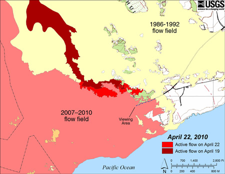
A fresh lava flow from the Pu’u ‘O’o eruption has advanced about a mile since early April 2010, and geologists believe if it continues on its current path, it will rejoin the older flow field on the coastal plain just west of the current viewing area near Kalapana (east of the Volanoes National Park).
There has been no ocean entry to wow spectators over the last few months, so certainly the tourism industry awaits the new flow anxiously. Lava from the east rift zone vent, flowing into a lava tube system, continued to supply surface flows that have advanced slowly to the southeast down the Pulama pali, east of the Royal Gardens subdivision. The flow front is still heading southeast along the east margin of the TEB flow field on the coastal plain and approaching the end of the Kalapana access road.
Yesterday, the lava creeping through the thickly vegetated kipuka north of the County viewing area trail had slowed significantly, while a much more vigorous lobe of lava a few hundred meters (yards) to the west was approaching the west side of the same kipuka. HVO scientists will visit the flow field again today to assess the current location of the flows. Although the first week of April 2010 saw many surface flows near the Kalapana Viewing Area, recent weeks has shifted the visible surface lava further uphill and away from the viewing area.


